Inertial Platforms are pretty crucial when it comes to navigation systems in all sorts of industries. As Dr. Emily Carter from Navigation Innovations put it, 'Getting better accuracy in navigation really depends on how well the Inertial Platform is working.' That really highlights how important it is to keep these systems in check and constantly working on improvements.
A lot of folks tend to overlook just how complex Inertial Platforms really are. If you don't do routine calibration, issues can creep in without you even realizing it. Plus, environmental stuff can mess with their performance—like temperature changes, which can throw off sensor accuracy pretty significantly. So, understanding these little quirks is a must.
The bottom line? The path to more accurate navigation isn’t a one-and-done deal. Surprisingly, many users still stick with old software or hardware instead of upgrading. It’s tempting to just keep using what you know, but that can really hold you back. Thinking about these hurdles honestly helps us stay proactive and stay ahead when it comes to mastering Inertial Platform tech.

Understanding Inertial Platforms and Their Role in Navigation
Inertial platforms play a vital role in navigation. They utilize sensors to track motion. These systems are essential for aircraft, marine vessels, and autonomous vehicles. Industry reports estimate that Imu Inertial systems can improve positional accuracy by up to 30%. However, they are not foolproof.
Gyroscopes and accelerometers are the core components of IMU inertial platforms. They constantly measure the rate of rotation and linear acceleration. This data helps in estimating the position. The accuracy of these readings can be affected by environmental factors. For instance, vibrations and temperature changes can introduce significant errors.
Despite advancements, calibration remains a challenge. Users must regularly check and adjust the systems. Without proper calibration, errors may compound over time. This can lead to navigation failures. It’s crucial to balance system complexity and reliability. A more sophisticated IMU inertial setup may not always result in better navigation. A deep understanding of these systems is essential for maximizing their performance.
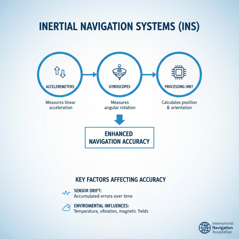
Key Components of Inertial Navigation Systems
Inertial navigation systems (INS) rely on key components to enhance navigation accuracy. These include accelerometers, gyroscopes, and the processing unit. Each component plays a critical role in providing precise position and orientation data. According to a recent report by the International Navigation Association, the accuracy of INS can be affected by various factors, including sensor drift and environmental influences.
Accelerometers measure linear motion. They detect changes in velocity, which is vital for tracking movement over time. Gyroscopes, on the other hand, are essential for measuring rotational changes. This combination enables the system to calculate the current location accurately. However, the effectiveness of these sensors can diminish in challenging conditions. For example, vibrations and temperature fluctuations may lead to inaccuracies, as cited in the Journal of Navigation.
Moreover, the processing unit integrates data from the sensors to compute the user's position. Advanced filtering algorithms help minimize the impact of noise and errors. Still, the choice of algorithms significantly affects performance. Some algorithms do not account for all variables. Thus, they may fail under specific conditions, highlighting areas for improvement. Ongoing research aims to refine these systems, aiming for higher accuracy in various scenarios.
Factors Affecting Navigation Accuracy in Inertial Platforms
Inertial platforms play a crucial role in navigation systems. Accuracy is often influenced by various factors. Noise from sensors can degrade data quality. Another challenge is temperature fluctuations, which can impact sensor performance. These elements make achieving consistent accuracy more complicated than expected.
Sensor calibration is essential. Improperly calibrated sensors lead to significant errors. Regular checks can help counteract this issue. Additionally, the integration of Inertial Gps can improve overall navigation accuracy. Combining inertial data with GPS signals offers more reliable positioning. However, it's important to note that even the best systems can have occasional discrepancies.
Environmental factors also play a role. Urban canyons or dense forests can weaken GPS signals. These situations create a reliance on inertial measurements. Errors due to drift in inertial systems can accumulate over time. Users need to remain aware of these limitations. Continuous monitoring and adjustments are necessary for optimal performance. It is essential to recognize that no system is flawless, and awareness of these issues can lead to smarter navigation strategies.
Techniques for Enhancing Sensor Calibration and Alignment
Calibrating and aligning inertial sensors is critical for enhancing navigation accuracy. Proper calibration reduces noise and drift in sensor readings. Studies reveal that improved calibration techniques can enhance accuracy by up to 50%. However, many systems still rely on outdated methods. This often leads to inconsistent performance in navigation systems.
One effective technique is the use of advanced algorithms. These can dynamically adjust to sensor biases in real-time. Research shows that integrating machine learning can improve alignment accuracy significantly. Yet, these methods require substantial computational resources. Not all platforms can support such advanced techniques.
Another common challenge is environmental factors. Temperature shifts can affect sensor performance. In some cases, misalignment occurs due to external vibrations. Reports indicate that a 10°C change can result in a 5% error in navigation systems. These issues highlight the ongoing need for continual sensor refinement. Engineers must constantly reevaluate calibration practices to ensure optimal performance in diverse conditions.
Integration of Inertial Platforms with Other Navigation Systems
Inertial platforms play a crucial role in navigation. When combined with
other navigation systems, their accuracy can significantly improve. For example, an
Inertial Nav
system uses accelerometers and gyroscopes to track movement. However, without external references, it can
drift over time. This is where integration is beneficial.
Combining Inertial Nav with GPS can enhance reliability. GPS provides
position fixes, reducing drift. In urban environments, multipath signals affect GPS accuracy. Here, an
integrated approach helps. The inertial data fills in gaps during weak signals. This blending creates a
smoother navigation experience.
Another option is to incorporate visual odometry. Cameras provide additional data points. This helps
correct errors in real-time. However, processing visual data can be intensive. Balancing speed and accuracy
is essential. Users may need to tweak settings for optimal outcomes. More research is needed to refine these
integrations, ensuring robust navigation solutions.
Real-World Applications of Inertial Navigation Technologies
Inertial navigation technologies are transforming navigation systems across various industries. These systems provide needed precision, especially when GPS signals are weak or unavailable. For instance, drones need to navigate through urban environments. They rely heavily on inertial platforms to maintain accuracy during flight. When GPS fails due to tall buildings or interference, inertial sensors keep the drone on track.
Marine navigation also benefits from inertial platforms. Ships and submarines use these systems to determine their position accurately underwater. GPS signals can disappear, so inertial navigation helps maintain a steady course. Operators often analyze sensor data to adjust their routes. However, minor errors can accumulate over time, leading to navigational issues. Regular calibration and data checks are essential.
In terrestrial applications, vehicles equipped with inertial navigation display impressive results. They can travel through tunnels or dense forests where GPS is unreliable. Yet, these systems are not infallible. They can drift over time, requiring periodic updates. Users must remain vigilant and routinely assess navigation data. Overall, the integration of Gps Inertial navigation significantly enhances accuracy but demands continuous monitoring.
Inertial Platform Tips for Improved Navigation Accuracy
| Application Area |
Technology Type |
Accuracy (m) |
Use Case |
Comments |
| Aerospace |
MEMS Inertial Sensors |
0.5 |
Flight Path Optimization |
High reliability in turbulent environments |
| Marine |
Fiber Optic Gyroscopes |
0.2 |
Submarine Navigation |
Excellent performance under water |
| Automotive |
Solid State IMU |
0.3 |
Autonomous Vehicles |
Real-time adjustments enhance safety |
| Mobile Devices |
Microelectromechanical Systems (MEMS) |
1.0 |
Smartphone Navigation |
Compact size with optimized performance |
| Industrial Robotics |
Ring Laser Gyroscopes |
0.05 |
Precision Task Execution |
High precision for complex maneuvers |
Future Trends in Inertial Navigation System Development
The future of inertial navigation systems (INS)
is exciting yet complex. As technology advances, the integration of artificial intelligence is becoming more prevalent. This shift could enhance data processing capabilities, allowing for quicker decision-making in navigation. However, the challenge lies in ensuring the reliability of AI algorithms. They must be rigorously tested to prevent errors in critical situations.
Another promising trend is miniaturization. As components shrink, we can expect more compact and lightweight INS units. This could revolutionize applications in drones and wearable devices. Yet, smaller size may compromise accuracy. Designing systems that balance size and precision is a significant undertaking. Engineers will need to innovate continuously to meet this demand.
Moreover, adaptive algorithms are gaining attention. These algorithms learn from real-time data to adjust navigation parameters. But, there’s a risk of overfitting to specific conditions, potentially leading to failures in diverse environments. It’s a delicate balance that developers must navigate. Continuous improvement and feedback loops will be essential to address these challenges and enhance INS performance.
FAQS
: Staying active improves mental and physical health. It boosts energy and mood. Regular exercise can enhance sleep quality.
Adults should aim for at least 150 minutes of moderate exercise weekly. Shorter sessions can still be effective. Even 10-minute bursts count.
Yes, physical activity reduces stress levels. It triggers endorphins that promote relaxation. Engaging in group activities can enhance these effects.
You can incorporate activity into daily routines. Take the stairs, walk during breaks, or do quick workouts at home. Every bit helps.
No, many effective exercises require no equipment. Bodyweight exercises, walking, and home routines can be done anywhere. Explore what fits you best.
Time management and motivation can be tough. Finding enjoyable activities may require some trial and error. Consistency can be hard but is crucial.
Conclusion
Inertial platforms play a crucial role in enhancing navigation accuracy across various applications by utilizing advanced sensor technologies. Understanding the fundamental components of inertial navigation systems, such as accelerometers and gyroscopes, is key to recognizing how these systems operate. However, several factors, including environmental conditions and sensor calibration, can impact navigation precision.
To improve accuracy, techniques for enhancing sensor calibration and alignment are essential, as is the integration of inertial platforms with other navigation systems, such as GPS. This combination not only bolsters reliability but also opens new avenues for real-world applications in fields like aerospace, robotics, and autonomous vehicles. Looking ahead, the development of inertial navigation systems will continue to evolve, incorporating innovative technologies that promise even greater accuracy and efficiency.
 TBSD60
 BSD120
 BSD98
BSD98 BSD70
BSD70 BSD60
BSD60 BSD50
BSD50 BSD217
 INS1700
 INS970
 INS570
 INS170
 SLA-4B1L1-65
 SLA-4B1L1-130
 SLA-8B1L1-165
 DIVER 101
 DIVER 102
 DIVER 103
 DIVER 104
 DIVER 105
 DIVER 106
 SLLR3000
 SLLR905
 SLLD25
 160M
160M 170M
170M SLFC-70
 SLAF280
 MR360
MR360